
The Schuylkill County Historical Society is following this blog on Facebook! I was so excited to learn this that I was determined to get to a marker in that county this month, and here we are.
Here's a fun fact which I didn't know until I started researching today's quest. Pennsylvania has actually, at different points in the 18th century, had two different places named Fort Franklin. One was in Venango County, which I've never visited, so I expect to be tackling that subject in a future post. The other, which is today's subject, was the first of its name and stood in Schuylkill County overlooking a scenic valley.
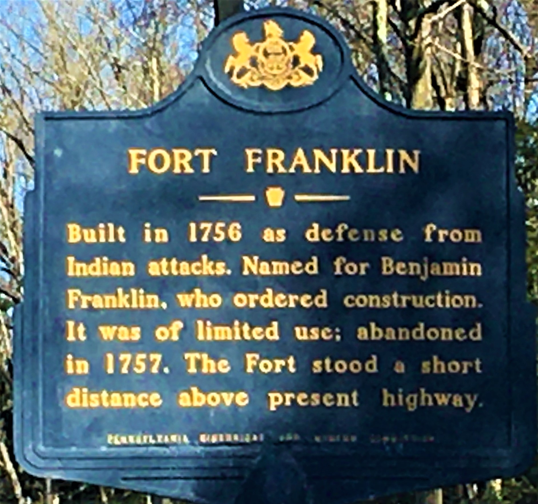 |
| The marker is on Route 309 south, near Blue Mountain Drive; the formal address for the location is 2308 West Penn Pike, Andreas. |
Here's what I can tell you. In 1754, the French and Indian War got started. France and Britain duked it out for dominance here in the New World, and would continue to do so until the Treaty of Paris was signed in 1763. They never did like each other much. While that was going on, in 1755, the Moravian settlement of Gnadenhuetten was attacked by Native Americans who were spurred into it by the French, and the residents were almost all killed. My longtime readers will remember that as being one of my earliest subjects; it's still one of my top five most read posts of all time.
In response to this slaughter of defenseless citizens, since Gnadenhuetten had no stockade or other defensive structure, Benjamin Franklin began laying out plans for a series of forts throughout the region. Among these were Fort Allen, Fort Everett (at the home of my direct ancestor John Everett), and today's subject, which was named Fort Franklin in his honor.
The official address of the marker is in the community of Andreas, but the fort itself may have been in the area known as Snyders; I'm not entirely clear where the border is, or was. It was constructed in 1756. A letter from Benjamin Franklin himself, sent to Governor Morris in January of that year, mentions the fort briefly; Franklin was at Fort Allen at the time. The letter says that Captain Charles Foulk, who had helped him establish Fort Allen, had been sent to "build another fort, between this and Schuylkill Fort". (Schuylkill Fort was later renamed Fort Lebanon; it stood northeast of what is today the community of Auburn, and - I know you're surprised - it has a marker of its own so we'll be visiting that later.)
Fort Franklin was also known in its day as "the fort above Allemangel." Allemangel is a German word meaning "all want," and the area given that name - known today as Albany Township in Berks County - was called so because it was extremely dry. The fort was not actually in Allemangel, but rather on the mountain which overlooks it. What we know about the design of the fort comes chiefly from a report by Commissary James Young, who conducted an inspection tour of several of Benjamin Franklin's forts in northeastern Pennsylvania, and he had this to say about it:
At ½ past 3 P.M. (June 21st, 1756) we sett out with the former Escort & 2 of Cap't Morgan's Comp’y (from Fort Lebanon) for the Fort above Alleminga, Commanded by Lieu't Ingle (of Capt. Morgan's Company, who was relieved by Lieut. Sam'l Humphreys); at ½ past 7 we got there; it is Ab't 19 miles N.E. from Fort Lebanon, the Road a Narrow Path very Hilly and Swampy; ab't half way we came thro' a very thick and dangerous Pine Swamp; very few Plantations on this Road, most of them Deserted, and the houses burnt down; ½ a mile to the Westward of this Fort is good Plantation, the people retires to the Fort every Night. This Fort stands ab’t a mile from the North Mountain; only two Plantations near it. This Fort is a square ab’t 40 foot, very ill staccaded, with 2 Logg houses at Opposite Corners for Bastions, all very unfit for Defence; the Staccades are very open in many Places, it stands on the Bank of a Creek, the Woods clear for 120 yards; the Lieu’t Ranges towards Fort Lebanon and Fort Allen’ ab’t 4 times a Week; much Thunder, Lightning, and Rain all Night. Provincial Stores: 28 G'd Muskets, 8 wants Repair, 16 Cartooch Boxes, 8 lb Powder, 24 lb Lead, & 12 Rounds for 36 men, 36 Blankets, 1 Axe, 1 Adse, 1 Auger, 2 Plains, 1 Hammer, 2 Shovels, 9 Small Tin Kettles.
I'm pretty sure that staccaded means stockaded in modern verbiage. Cartooch boxes are cartridge boxes, in which soldiers would carry ammunition. I'm not absolutely certain what an adse is, but on trying to find out, I learned about an adze, which is a tool not entirely unlike an axe; that might be what he's referencing.
In any case, it seems that, to judge by this report, Young was not particularly impressed with Fort Franklin, given that he described it as ill stockaded and unfit for defense. It also had a garrison of fewer than 70 men, and it was not used much. Eventually, what garrison it had withdrew and transferred to Fort Everett, and the fort fell into disuse in 1757. When it was torn down is unclear, but no trace remains of the 40-foot square palisade nor of the three buildings which stood within it.
Thomas Lynch Montgomery, in the early 20th century, undertook the search for several of the 'lost' forts of the frontier era, and it's thanks to his work that we know most of what we know about Fort Franklin's location. It was not on the bank of the Lizard Creek, as some have stated, but rather along a smaller creek to the south, which joins the Lizard to the northeast. It stood nineteen miles from Fort Lebanon, fourteen from Fort Allen, and was situated on what was at one time a piece of property known as the Bolich farm. It sat directly on the road which led to Fort Everett, but whether that's the same highway on which the marker stands today, I have no idea.
"We could wish," Montgomery wrote, "from the name it bore, that this fort, might have been amongst the more important ones. Unfortunately such was not the case. Poorly constructed in the first place, in the next place its location was in a part of the Province as yet but poorly settled. ... I think it is doubtful whether the fort would ever have been built except to fill in the long gap in the chain of defenses between Forts Allen and Lebanon."
Despite its brief and uneventful existence, however, Montgomery was firmly of the mind that Fort Franklin was deserving of recognition. "It was one of the regular chain of forts and its position should be marked; I would recommend a tablet, in close proximity to its site, along the public road to Lynnport." His wish was granted in 1955, when this marker was erected. Fort Franklin is long gone, and without Montgomery's efforts, it might have been completely forgotten. Instead, we have a blue and gold reminder.
Sources and Further Reading:
Except where indicated, all writing and photography on this blog is the intellectual property of Laura Klotz. This blog is written with permission of the Pennsylvania Historical and Museum Commission. I am not employed by the PHMC. All rights reserved.
As always a great article . From what I’ve read, fort Franklin was erected on the flat area to the north of the marker by Rt. 895 ( why it was erected on the “ wild” side of the blue mountain is anyone’s guess)
ReplyDeleteThanks Dave!
DeleteI live very close to this area and have done a lot of research on this. I am convinced that by all of the descriptions I have come across, it is located where a home now stands... 1 Fort Franklin Road. The home is right on the creek bank, with a large clearing between it and the woods, and it has a commanding view of the county.
ReplyDeleteThat's really interesting, thank you so much for sharing! I wonder if we'll ever know for sure, but it certainly sounds like you might have the answer.
DeleteLaura, thanks for researching this. I got a wild impulse this afternoon to look up the location of Fort Franklin and found your blogpost. My direct ancestor was the Charles Foulke you mention in your article. The family story that had been passed down to us was that our ancestor had been put in charge of building the fort for frontier defense, and that Ben Franklin himself had come to inspect it. We also had a family story about the Indian attack you describe. I don't think any family members were reported as killed or abducted, but the description was pretty horrific -- people being burned inside their homes, etc.
ReplyDeleteOur family were Rhineland German Protestants who originally settled around Newburgh, NY about 1710. The British wanted more settlements on what was then the frontier, and they welcomed Protestants. Then they relocated to Pennsylvania and found themselves once again on the hostile frontier. Their original German name was Volk. Because the V in German is sounded as F, it evolved in New York to Folk or Foulke and eventually to Faulk, which was my mother's family name. Glad to make this connection to a bit of our shared history.
Randy Horick
Nashville, TN
Thank you so much for reading and sharing this! I always love hearing from people with a personal connection to our history!
DeleteLaura an adze is a wood cutting tool used to flatten the sides of logs to make walls for log cabins. It is used by usually standing ON the log you are cutting or you straddle the log and then cut towards yourself. The tool is made of metal with a wooden handle. Looks sort of like an axe on its side with the blade parallel to the wood you are cutting and curved back towards you. Any time you see a cabin built prior to 1900 an adventure was likely used. Some still do today for authenticity in the cabin being built. You can Google it to see what thlook like.
ReplyDeleteThank you so much for this! I appreciate the clarification - yes, it sounds like what was being referenced was indeed an adze.
DeleteThis was of great interest. My immigrant ancestor, John Eckenroad, quartered some of the Ft Franklin troops at his house which was not far from Everett's. I have no direct proof but am guessing he knew Benjamin Franklin since numerous men in my family have been named that.
ReplyDeleteIn the late 1950s and into the 1960s, there was a picnic area with parking and a few tables at the site of Fort Franklin. We often drove up from Allentown for a short hike on the nearby Appalachian Trail and a picnic out in the country.
ReplyDelete