
Edit 8/20/2025: This post has been updated! For the more recent version, click here.
I mostly know Weissport as the little town under the route 209 bridge, which every August hangs up signs advertising their "Redneck Festival" over Labor Day weekend. I also know it from my article about Gnadenhütten, where I mentioned that Weissport was eventually formed from two of the three Moravian settlements by that name.
In the Gnadenhütten article, I mentioned that Fort Allen was built as a direct result of the attack on the Moravians, and that I'd be getting to that in a later post - and here we are. This is another two-fer, because there are two markers connected to the fort; the well, which is the only part of the fort still existing today, has a marker all its own.
Before I get started, I want to give a word of caution about this particular marker. I keep my own list of where to find these things, so that when I'm out and about on unrelated matters I can 'catch' them as if they were wayward Pokemon. This one's location I noted as death trap. I was of course being facetious, but it actually is a little dangerous, because there's no place where you can pull over safely to read or photograph the marker. I didn't actually take this picture; my best friend Andrea did, from the passenger seat of my car while I was driving (very slowly) past it. So if you go marker hunting for yourself, and you want to 'catch' this one, please be careful.
On with the show. As we know from the research about the Moravian settlement, Fort Allen was erected in direct response to the massacre across the river in what is now Lehighton. Benjamin Franklin himself came to oversee the planning; with multiple similar attacks happening, people in the area were in an understandable state of alarm, and efforts to protect them by posting soldiers just weren't cutting it. A fort was needed, and one of the commissioners of the army was needed to come to the Lehigh Valley and make the arrangements. Franklin was the commissioner chosen, and he immediately set out for Bethlehem, and thence to what is now Weissport. He arrived there the day after his own fiftieth birthday, and his first letter to Governor Morris talks about the difficulties the people were facing, and those he faced himself in bringing order out of chaos.
Construction of the fort began in January 1756. They used wood purchased from Drucker's Mill in nearby Slatington, then still called Kernsville; Drucker's Mill (or Trucker's Mill, spellings vary) has its own marker. Franklin's official reports and personal diary reflect the difficulties he had with January weather, which will come as no surprise to anyone who has seen a Pennsylvania winter. Lots of rain, lots of fog. Toward the end of January, one of his reports mentions a trek to Bethlehem for supplies, and how he returned with a number of soldiers and "7 Waggons, laden with Stores and Provisions." He also notes that the second day of the trip saw them traveling very cautiously, "the Roads being bad and the Waggons moving slowly." (Spellings and capitalization are his.) Franklin was a busy man, since he was not only personally overseeing the construction of Fort Allen, but also dispatching people to handle the construction of Fort Franklin, in Schuylkill County, and Fort Norris, in Monroe County.
Fort Allen was completed within a week and named in honor of William Allen, who at the time was the Chief Justice, and a former mayor of Philadelphia. (Allen later founded the nearby city of Allentown, now the third-largest city in the state; his son James had a house there, Trout Hall, which will be the subject of a future post.) The fort's stockade - that is, the guard wall - was vaguely star-shaped; it was twelve feet high, 125 feet long, and 50 feet wide. There were two half bastions on opposite corners of the long walls, each with a mounted swivel gun, and a full bastion in the middle of each of the long sides. Within the stockade were officers' quarters, two barracks buildings, and a well that went 19 feet deep, known as the Franklin Well. A map of the fort's layout can be viewed on the Fort Wiki. Franklin himself had to leave almost immediately after the place was finished, as he was summoned back to Philadelphia by the governor to participate in the Assembly.
Fort Allen's history is short and lively. A letter to Governor Morris from Major William Parsons, in the state archives, details information he received from a Native American whom he calls Ben; it talks about an unnamed lieutenant, stationed at the fort while his captain was in Philadelphia, who dealt very unfairly with the Delaware chief Teedyuscung. He cheated the chief out of several deerskins by getting him drunk on very strong rum, which he apparently stole. Meanwhile, a non-commissioned officer named Corporal Christian Weyrick apparently decided to incite a mutiny, which the unnamed lieutenant didn't bother to suppress, and Major Parsons requested in his letter that both men be arrested. All of this took place in the summer of 1756, the same year that the fort was built.
What became of the guilty officers after they were taken to Easton for trial is unknown, but the rest of those stationed at Fort Allen were basically traded with the ones at Fort Norris. Captain Jacob Orndt, who headed the men brought from Fort Norris, wrote a letter the following summer requesting a new lieutenant, because the one under his command ran away with another man's wife. The request was granted and a man identified as Ensign Conrad was commissioned to be the new lieutenant.
Fort Allen remained garrisoned regularly until 1761, after which it was somewhat abandoned. Soldiers occasionally occupied it, but its primary use after that was as a shelter for the nearby townsfolk in times of crisis. The exception was in 1780, when 112 soldiers were stationed in and near the fort because fifteen locals, including all the members of the Gilbert family, had been taken prisoner by a group of Native Americans from various tribes. Among those who participated in the capture was Roland (or Rowland) Montour, a member of the family for whom Montour County would later be named; he was the husband of a Seneca chief's daughter and fought on the British side of the Revolution. Their story, first published in 1784 as The Captivity of Benjamin Gilbert and His Family, 1780-1783, has since been reprinted with various different titles. Those who survived captivity were eventually reunited. Meanwhile, Fort Allen remained garrisoned for much of 1780 to guard the rest of the neighborhood, but it was ultimately dismantled during that same year.
Well, most of it.
The well - Franklin Well, as it was called then, and Fort Allen Well as it's known now - is still standing. Weissport Park, a little public recreation spot just below the route 209 bridge, is home to both the marker for the well and a monument to Benjamin Franklin. The well itself is located behind Jacobs United Church of Christ, on Franklin Street, and is remarkably well preserved... no pun intended.

Strange to think that this is all that remains of Ben Franklin's efforts to protect the people of Carbon County. But Weissport doesn't forget that it was once called New Gnadenhuetten, or that he came to them in their time of need.
 |
| The marker is on route 209 southbound, north side, about a mile from where the fort actually stood |
On with the show. As we know from the research about the Moravian settlement, Fort Allen was erected in direct response to the massacre across the river in what is now Lehighton. Benjamin Franklin himself came to oversee the planning; with multiple similar attacks happening, people in the area were in an understandable state of alarm, and efforts to protect them by posting soldiers just weren't cutting it. A fort was needed, and one of the commissioners of the army was needed to come to the Lehigh Valley and make the arrangements. Franklin was the commissioner chosen, and he immediately set out for Bethlehem, and thence to what is now Weissport. He arrived there the day after his own fiftieth birthday, and his first letter to Governor Morris talks about the difficulties the people were facing, and those he faced himself in bringing order out of chaos.
Construction of the fort began in January 1756. They used wood purchased from Drucker's Mill in nearby Slatington, then still called Kernsville; Drucker's Mill (or Trucker's Mill, spellings vary) has its own marker. Franklin's official reports and personal diary reflect the difficulties he had with January weather, which will come as no surprise to anyone who has seen a Pennsylvania winter. Lots of rain, lots of fog. Toward the end of January, one of his reports mentions a trek to Bethlehem for supplies, and how he returned with a number of soldiers and "7 Waggons, laden with Stores and Provisions." He also notes that the second day of the trip saw them traveling very cautiously, "the Roads being bad and the Waggons moving slowly." (Spellings and capitalization are his.) Franklin was a busy man, since he was not only personally overseeing the construction of Fort Allen, but also dispatching people to handle the construction of Fort Franklin, in Schuylkill County, and Fort Norris, in Monroe County.
 |
| Monument to Benjamin Franklin and Fort Allen in Weissport Park, on Franklin Street |
 |
| The plaque on Franklin's statue. Note that 1922 refers to the year that the statue was erected; the fort was demolished long before that. |
What became of the guilty officers after they were taken to Easton for trial is unknown, but the rest of those stationed at Fort Allen were basically traded with the ones at Fort Norris. Captain Jacob Orndt, who headed the men brought from Fort Norris, wrote a letter the following summer requesting a new lieutenant, because the one under his command ran away with another man's wife. The request was granted and a man identified as Ensign Conrad was commissioned to be the new lieutenant.
 |
| Marker is found in Weissport Park on Franklin Street |
Well, most of it.
The well - Franklin Well, as it was called then, and Fort Allen Well as it's known now - is still standing. Weissport Park, a little public recreation spot just below the route 209 bridge, is home to both the marker for the well and a monument to Benjamin Franklin. The well itself is located behind Jacobs United Church of Christ, on Franklin Street, and is remarkably well preserved... no pun intended.
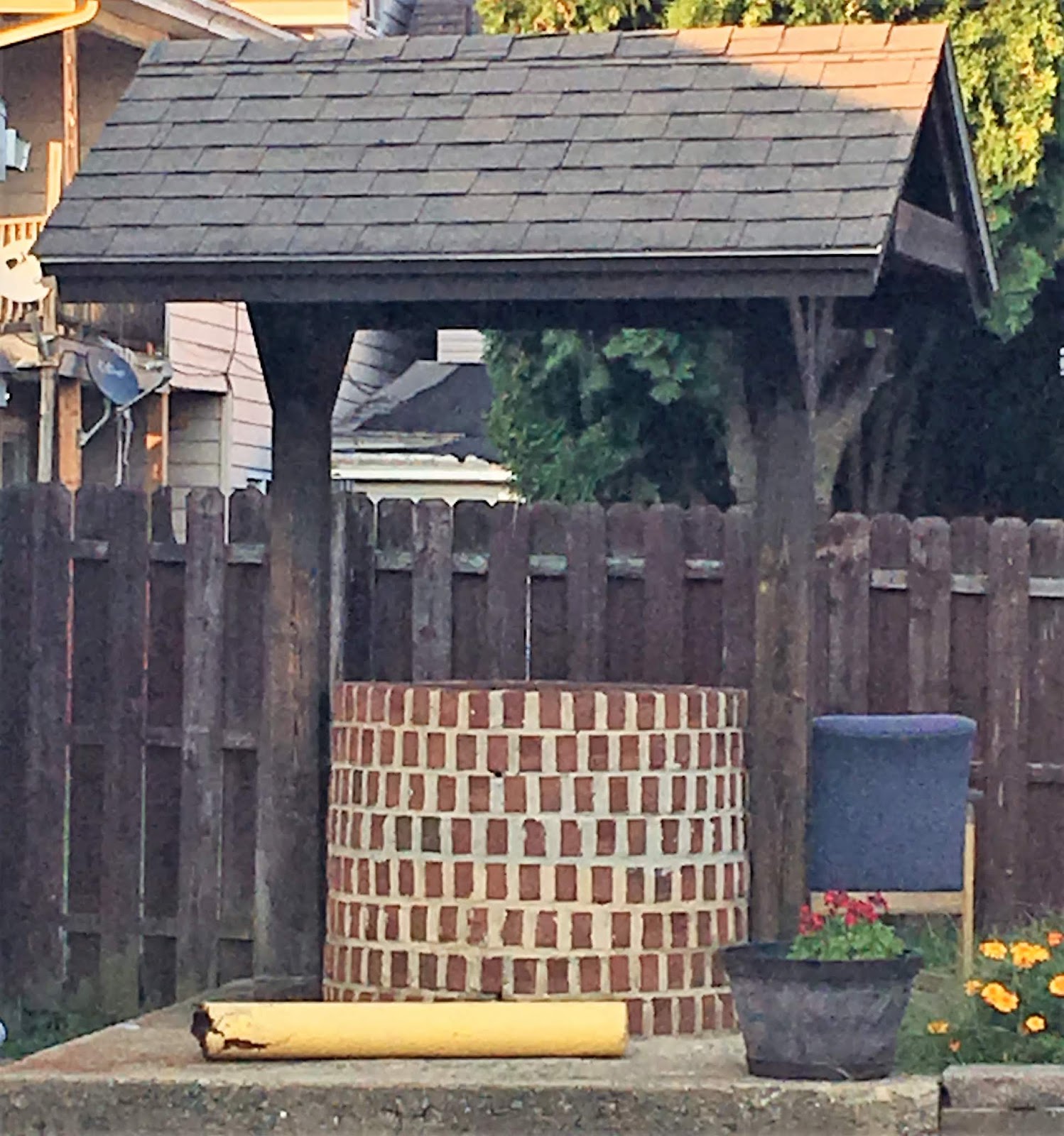
Strange to think that this is all that remains of Ben Franklin's efforts to protect the people of Carbon County. But Weissport doesn't forget that it was once called New Gnadenhuetten, or that he came to them in their time of need.
Sources and Further Reading:
Montgomery, Thomas Lynch. Report of the Commission to Locate the Site of the Frontier Forts of Pennsylvania, Vol. 1. Published 1916; transcribed for the USGenWeb Archives by Georgette Ochs.
Pauff, Georgie. "Ben Franklin Built Outpost in Weissport." The Morning Call, January 13, 2000.
Elliott, Ella Zerbey. Blue Book of Schuylkill County: Who Was Who and Why. Published by the Pottsville, PA Republican, 1915.
NorthAmericanForts.com
Fort Allen and Fort Allen Well at the Historical Marker Database
Except where indicated, all writing and photography on this blog is the intellectual property of Laura Klotz. This blog is written with permission of the Pennsylvania Historical and Museum Commission. I am not employed by the PHMC. All rights reserved.
Fort Allen and Fort Allen Well at the Historical Marker Database
If you've enjoyed this, please leave a comment!
Except where indicated, all writing and photography on this blog is the intellectual property of Laura Klotz. This blog is written with permission of the Pennsylvania Historical and Museum Commission. I am not employed by the PHMC. All rights reserved.
I am fairly new to the area and am learning a great deal of local history from your articles. Being interested in local history and lore wherever I am, it is a pleasure to have found your site. After I read your information I try to follow up with a visit to each one of the places you describe.
ReplyDeleteAll of my life I have photographed historical markers, and I like knowing I am not alone. Thanks for all of your knowledge and willingness to share it.
Marie
Laura, your old drama coach can still recognize your writing style! Since moving near Lehighton and Weissport, you are filling in the holes in my local history knowledge.
ReplyDeleteSee you at the next redneck festival! 😉